Glossary
Benchmark
A community-trusted, standardized dataset and evaluation protocol used to measure how well a geospatial foundation model's embeddings perform across a set of downstream tasks.
Cloud Optimized GeoTIFF (COG)
A regular GeoTIFF file aimed at being hosted on an HTTP file server, with an internal organization that enables more efficient workflows on the cloud.
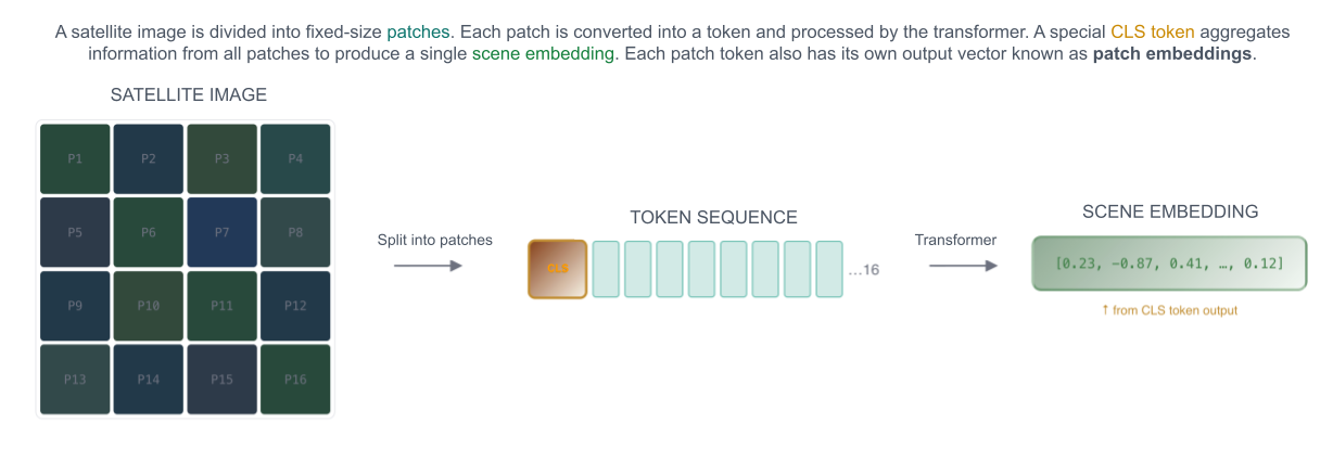
CLS Token
A summary token whose output vector represents the entire image as a single embedding, rather than any individual patch.
Embedding Quantization
Quantization reduces the precision of each number in the embedding vector. Less memory, faster search — with a small accuracy tradeoff.

Embedding Size
The number of dimensions in the embedding vector, also referred to as the length of the embedding vector. For example, Google AlphaEarth has 64 dimensions.
Features
Inputs to a model. This is context-dependent and could refer to raw pixel values, engineered features, or embeddings if they are used as input into a downstream model.
Few-shot
Fine-tuning or prompting a model with only a handful of labeled examples (typically 5–50) per class.
Fine-tuning
Updating some or all of a foundation model's pre-trained weights on a smaller, task-specific dataset to adapt its learned representations to a particular downstream application.
GeoParquet
A format for storing geospatial data in Parquet tables with geometry and spatial metadata, making it efficient for large-scale geospatial analytics and cloud processing.
Geospatial Embedding
A numerical vector produced by a trained model that encodes the meaningful properties of geospatial data into a continuous vector space.
Example types:
- Pixel Time Series Embeddings — Derived from the temporal sequence of satellite observations at a single pixel location rather than from a spatial image chip (Example: Presto)
- Spatiotemporal Window Embeddings — Produced by processing a stack of image chips at the same location across multiple timestamps, capturing both spatial and temporal patterns (Example: OlmoEarth)
Latent Space
The vector space in which embeddings exist. Each embedding occupies a point in this space, and the structure of the space encodes semantic relationships — similar places are positioned nearby, dissimilar places are far apart.
Linear Probing
A technique used to evaluate the quality of features (embeddings) by training a simple, shallow linear classifier (a "probe") on top of embeddings.
Multimodal
In remote sensing: Often referred to as multi-sensor — when multiple different sensors are used as inputs. This doesn't necessarily require multiple modalities. For example, it could refer to using Sentinel-2 + Landsat together (both optical), but could also refer to using Sentinel-2 (optical) + Sentinel-1 (SAR) together.
In embeddings: When multiple different input modalities are used. This could refer to using Sentinel-2 and Sentinel-1 together, but could also include data such as text, climate, or elevation data. Generally would not include using multiple sensors of the same modality (e.g., Sentinel-2 + Landsat, both optical).
Patch
In remote sensing: Analogous to an image chip, window, or tile — a spatial subset or window read from a larger image.
In embeddings: The spatial window used to compute tokens in an embedding model. For example, Clay uses an 8×8 patch size.
PCA
Principal Component Analysis. A linear method that projects high-dimensional embeddings into a lower-dimensional space (usually 2D or 3D) while preserving as much global variance as possible for visualization.
Pretraining
Learning general-purpose geospatial representations from large unlabeled Earth observation datasets. Typically done by researchers who produce and publish embeddings and models to generate them from different modalities.
Scene Embedding
A single vector representation that captures the overall characteristics of an entire image tile or geographic scene, as opposed to patch-level embeddings that describe individual pieces of it. Typically derived from the CLS token or by pooling all patch embeddings together.
Similarity Search
A technique used to find data points that are mathematically "close" to a given query within the vector space.
Common methods:
- Cosine similarity
- Dot product
- Euclidean distance

t-SNE
t-distributed Stochastic Neighbor Embedding. A nonlinear method that visualizes embeddings by mapping them to 2D or 3D while preserving local similarity, so points that are close in embedding space appear close in the plot.
Zarr
A format for storing large multidimensional arrays in chunked form. Designed for high-performance, parallel computing and cloud-native storage (e.g., S3, Google Cloud Storage) by breaking arrays into small, independently readable binary chunks. This is the preferred format for publishing regularly gridded embeddings.
Zero-shot
Using pretrained embeddings directly for a task without any additional training or fine-tuning. Performance is usually lower than fine-tuned, but it requires zero labeled data.